Right now, with the higher than average temperatures, the snow pack is melting very fast and is causing flooding in the creeks. It has prompted the National Weather Service to issue a Flood Advisory.
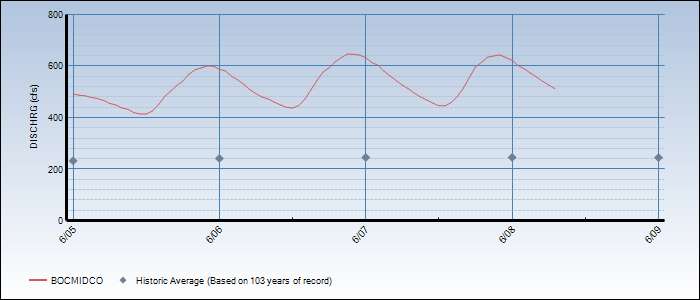
It’s interesting looking at the oscillations in creek flow over the course of a day. Below is a graph of the flow rate into Barker Reservoir.
It peaks at about 9 PM each evening. Assuming that the peak snowmelt happens at 3PM (a wild guess based on the peak temperature), it takes 6 hours for that water to travel the various streams and reach Barker Reservoir.
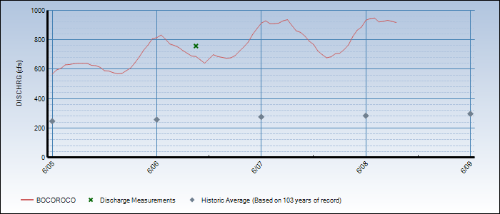
Further downstream, about 15 miles down Boulder Canyon, the peak flow rate is at about 1 – 3 AM each night. It’s a little more bumpy looking because North Boulder Creek and Middle Boulder Creek have merged and they probably have slightly different peaks. Also, normally the dam at Barker would smooth out the bumps, but since the water is spilling over the dam, it isn’t a factor.
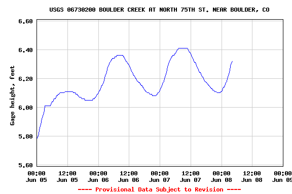
And still further downstream, east of Boulder near Walden Ponds, the peak flow rate is about 8 – 9 AM.
So, from snowpack to Walden Ponds, it takes about 18 hours for the water to travel that distance.
And something I learned last year when I nearly got stuck driving across a creek, the highest water level each day may not be when you think it is.
Edited to add:
The city of Boulder was built in a flood plain. If a hundred-year flood ever happens, it will likely occur in the middle of the night.


