After experiencing the driest second quarter (April, May, June) in recorded history, a dozen wildfires across the state, a wildflower-less landscape, and record breaking temperatures and dry wind, the rains have finally come. I’ve received nearly 3 inches of precipitation over the past 3 days. A little more is expected today. Now, of course, the weather service has issued a flash flood watch.
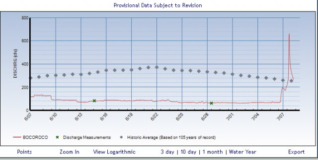
The graph below shows the flow in Boulder Creek east of the dam. Note that the water levels were about 1/4 of the historic average before the recent storms which are shown by the spike at the end of the graph.
April, May, June are statistically our wettest months.
* * *
Regarding the media coverage of forest fires, they commonly cite that the fires are worse due to the mountain pine beetle killing the trees. In one local case, they stated the fire was burning in a tinder-dry beetle killed forest, when I knew for a fact there were very few beetle killed trees in that area. They will stop at no lengths to sensationalize a story.
The problem is, as we learned with the Bush administration, if you repeat something enough times, it becomes true in people’s minds. This leads people to thinking that the pine beetles have to be dealt with in some way. For example a large part of the forest near where I live, where people hike, camp, and ride bikes is going to be “patch cut”. Patch cutting is removing all of the trees in large areas, similar to clear-cutting.
Remove the trees, and yes, the pine beetle “problem” goes away for obvious reasons.
Pine beetles have always been a part of the forests here. They have been documented as being around for at least a hundred years and are probably a native species. Their job is to keep the forests from getting overgrown, just like natural fires. Based on my own observations, they don’t kill all of the trees. Thirty to forty percent continue to live.
Here is the link to the article:
CU-Boulder researchers: Pine beetles not always tied to increased fire danger

